From NW District Foresters:
We have a “significant weather pattern shift” beginning today, August 26th. For most of this fire season, we have enjoyed seasonable temperatures and relative humidity levels. The first part of this week we will see a significant warm-up coupled with a significant drop in the RH (relative humidity). A Fire Weather Watch has been posted for the eastern part of our district for tomorrow, and a Red Flag Warning for the Willamette Valley is already posted for today.
With these conditions in mind, the Northwest Protection Association will be moving NW 2 and NW 3 to an Industrial Fire Precaution Level 2 as of August 27, 2019, at 0100. NW 1 will remain and IFPL Level 1.
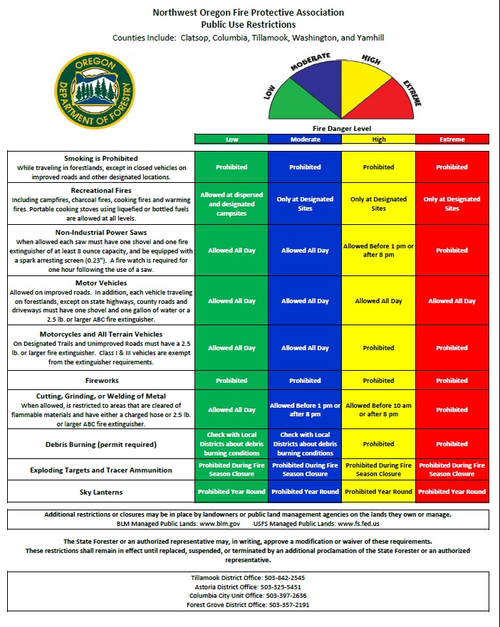
In addition, Public Use restrictions will move from Moderate to HIGH. The change in Public Use means all current restrictions remain in place and the High Fire Danger Level prohibits the use of motorcycles and all-terrain vehicles on trails.
You can check the below websites for additional information:
https://www.oregon.gov/ODF/Fire/Pages/Restrictions.aspx
http://tillamookstateforest.blogspot.com/

Fortunately this new weather system is predicted to be relatively short-lived.
Below is a portion of the written forecast from the National Weather Service that provides some more detail. Please be safe during these elevated fire conditions!
From the National Weather Service:
A significant weather pattern shift will begin on Monday, as upper level high pressure over the southwest U.S. begins to build up the West Coast. The ridge of high pressure will move directly over the region on Tuesday and Wednesday, likely resulting in the hottest temperatures since a warm stretch in mid-June. With the ridge moving overhead, a surface thermal trough over northern California and southern Oregon will build northward into the district on Monday, then strengthen over the next couple of days. Confidence is increasing that this will lead to a period of gusty offshore winds Monday night and Tuesday, which coupled with the hot and dry airmass, is expected to result in critical fire weather conditions for portions of the Willamette Valley and east slopes of the Coast Range. The thermal trough is modeled to be directly over the valley on Wednesday, so hot, dry, and unstable conditions may be a concern as well. With a subsidence inversion developing under the ridge axis, overnight humidity recoveries will be moderate to poor on Monday and Tuesday nights.

