By Gordon McCraw, Meteorologist for the Tillamook County Pioneer
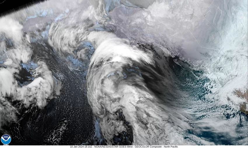
That was a quick round two of exciting winds and rain. It looks like the area saw between ¾” to 2” of rain in the last 24 hours and we saw the winds kicking up to around 35-45 in town as a front and an associated low pressure system pushed through. As I warned, this system ended up giving a few folks a little snow including Cannon Beach and across the Coast Range. Other areas reporting snow were Portland, the Gorge and Hood River areas, on up into Washington and Vancouver. While I write this, the sun is still not up but the webcam at Lees Camp shows precipitation that appears to be snow, with a temperature of 32.7 which is at 589’ so the summit is likely still accumulating snow. ODOT is reporting on Tripcheck that it was snowing hard and continuous at 4am this morning, the temperature was 32 with 6” of snow roadside and 1” of near snow. There were chain restrictions between MP27 to MP38. Also noteworthy is that the rivers did rise some but did not reach Action Stage. Another thing to note is the chance of Tidal Overflow Flooding due to the fact that we are having some higher surf conditions, combining with the elevated rivers, on top of some Astronomically High Tides which are running nearly a foot higher than forecasted also. The King Tide peak tomorrow and Friday. This means that all the usual overflow area suspects, including the North Main area near The Fern, will likely see water on those roads during the high tide times which are around lunchtime and near midnight today.
So, we are looking at some more cold, unstable air over the region and this will bring us rainshowers today, with that chance of thunderstorms again, staying breezy today with winds westerly 10-15 gusting to 25 around the heavier shower as they move across, the high today near 47. The snow level lifting to near 1300’ later this morning, then up to near 1900’ this afternoon. You see more showers and possible thunderstorms tonight through around midnight, winds westerly 5-10, the low near 38 so low level snow is unlikely.
We were hoping the models would come into better agreement on the forecast from Thursday on, but things are just to complicated for even the models. There is the Arctic Airmass that is expected to drop down from Canada, and we see another trough off the coast, and a low pressure system approaching the coast. These are all the major players, and the issue is how will they all interact and the timing. The approaching low pressure system will drive how far southwest the Arctic Air will intrude. There is still a large difference in the models on the temperatures, some are warmer, some are very cold. As we will be continuing to see falling moisture over the period, warmer means we see more rain, colder means we will see some accumulating snow, especially over the Coast Range eastward.
And now that I have given you all the reasons this forecast is difficult and causing the lack of confidence, I will continue with the forecast.
For tomorrow, we see another system bringing in more rain and breezy westerly winds 15-20 gusting to 30, the high near 47. More rain tomorrow night, the snow level starts to fall again, down to near 1500’, the winds increasing to 20-25 gusting to near 40, the low near 37. This means the summit will be seeing more snow.
Friday sees more rain and lowering snow levels, down to near 1300’ with the winds becoming southerly 10-15 gusting to 20, highs near 46. Rain, a rain/snow mix, or just snow Friday night as the temperature drops to near 33, still breezy so the windchill will make it feel like the 20s.
Now Saturday and Sunday are when the confidence really takes a dump. We are seeing another wet and windy system moving in and here is when the gap in model’s temperatures really takes place. The warmer temperatures spell a wet weekend, the colder solutions equal accumulating snow for many, especially in the Coast Range and eastward into the valley. The rivers will be on the rise again but are not currently expected to cause river flooding.
Officially, the forecast for the weekend is rain likely, and possibly some snow, breezy, the snow level starts higher then falls Saturday night into Sunday. Saturday’s temperatures are 43 for the high, 28 for the low, then Sunday a high near 43, and the low near 25.
The forecast remains nearly the same for MLK Day, highs near 42, lows near 28, along with a slight chance of rain or snow.
Currently, and subject to change, the only Advisories, Watches or Warning for the Tillamook area is the High Surf Warning that is valid thru 10AM this morning and the Coastal Flood Advisory related to the Tidal Overflow Flooding from 9AM this morning thru 2PM, the high tide times.
LISTEN HERE:


