Menu
  • Home
  • Breaking News
  • Feature
    • Arts
    • Astrology
    • Business
    • Community
    • Employment
    • Event Stories
    • From the Pioneer
    • Government
    • Letters to the Editor
    • Non Profit News
    • Obituary
    • Public Safety
    • Podcast Interview Articles
    • Pioneer Pulse Podcast: Politics, Palette, and Planet – the Playlist
  • Weather
  • Guest Column
    • Perspectives
    • Don Backman Photos
    • Ardent Gourmet
    • Kitchen Maven
    • I’ve been thinking
    • Jim Heffernan
    • The Littoral Life
    • Neal Lemery
    • View From Here
    • Virginia Carrell Prowell
    • Words of Wisdom
  • Things to do
    • Calendar
    • Tillamook County Parks
    • Tillamook County Hikes
    • Whale Watching
    • Tillamook County Library
    • SOS Community Calendar
  • About
    • Contribute
    • Advertise
    • Subscribe
    • Opt-out preferences
  • Post Submission Test
  • Search...
Menu

GORDON’S UPDATE: Weather 1/11/23 – Another low pressure system (or two) lining up …

Posted on January 11, 2023 by Editor

Wednesday, January 11, 2023

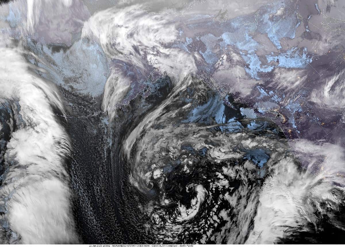
Today’s picture is, we have another large low pressure system west of Oregon in the eastern Pacific that will meander around for the next several days. The associated front and atmospheric river that was pounding California is shifting northward into Oregon and we see the rain returning and persisting thru Friday. The models are showing this to be a weak to moderate atmospheric river event that will bring the area 1-2” of rain thru tomorrow into Friday with maybe 2-3” in the Coast Range. A look at the river forecasts shows an increase in the flow rates that do push the rivers up some, but river flooding concerns remain low. As has been the pattern with the high pressure ridge to the east and the low pressure center to the west that causes a tighter pressure gradient, it will again give us breezy east winds, especially over the coastal waters and thru the passes. We do have a Gale Warning in effect from this evening thru tomorrow morning over the coastal waters with seas 12-14’ expected thru tomorrow night into Friday.

So, with all that said, tonight’s forecast is rainy with breezy east winds 10-15 gusting to 30, lows near 46.

Rainy still tomorrow with southeasterly winds 10-15 gusting to 20-25, highs near 57, lows near 48.

Friday, we start to see the jet stream returning to a more zonal flow like before, pointed towards California again. This means we can expect the rain here to ease a little along with the winds becoming southerly 5-10 with highs near 55, lows near 46.

The next low pressure area will push in the next round of rain by Saturday thru Sunday, highs near 52, lows near 43 then another low forms and gets pushed towards the coast bringing another round of rain Monday into Tuesday, highs near 50, lows near 40.

To give you an idea of what California is going thru with all the rain — there are some areas that have gotten 400-600% of their “normal” rainfall so far, which for some equals 36” of rain since Christmas. This has caused 17 deaths so far and there are about 142,000 people currently without power. It is reported that there are tens of thousands of people under an evacuation order from the rains and flooding with another 10” of rain expected this week. Up in the Sierra Nevada mountains, they are experiencing high winds with blowing snow reducing visibility to zero and there is an Avalanche Watch in effect with another 16” of snow expected on top of the feet already there with 50mph winds on top of that. The list of Advisories, Watches and Warnings this morning in northern California is, as you can imagine, quite long.

Featured Video

Slide Contribute SUBSCRIBE

Tillamook Weather

Tides

Tillamook County Pioneer Podcast Series

Tillamook Church Search

Cloverdale Baptist Church
Nestucca Valley Presbyterian
Tillamook Ecumenical Service

Archives

  • Home
  • EULA Privacy Policy
  • Contact
  • Opt-out preferences
  • Search...
Share on facebook
Facebook
Share on pinterest
Pinterest
Share on twitter
Twitter
Share on linkedin
Linkedin
Catherine

Recent Posts

  • TILLAMOOK COUNTY PIONEER WEEK IN REVIEW 5/8/25

    May 8, 2025
  • Exciting News for North County Recreation District – Congratulations to Barbara McCann on Retirement; Welcome New Executive Director, Justin Smith; Special Saturday Swims this Spring to Honor Legacy Pool – May 10 & June 14

    May 8, 2025
  • "I Pledge Allegiance" ... We Take an Oath

    May 8, 2025
©2025 | Theme by SuperbThemes

Manage Cookie Consent
To provide the best experiences, we use technologies like cookies to store and/or access device information. Consenting to these technologies will allow us to process data such as browsing behavior or unique IDs on this site. Not consenting or withdrawing consent, may adversely affect certain features and functions.
Functional Always active
The technical storage or access is strictly necessary for the legitimate purpose of enabling the use of a specific service explicitly requested by the subscriber or user, or for the sole purpose of carrying out the transmission of a communication over an electronic communications network.
Preferences
The technical storage or access is necessary for the legitimate purpose of storing preferences that are not requested by the subscriber or user.
Statistics
The technical storage or access that is used exclusively for statistical purposes. The technical storage or access that is used exclusively for anonymous statistical purposes. Without a subpoena, voluntary compliance on the part of your Internet Service Provider, or additional records from a third party, information stored or retrieved for this purpose alone cannot usually be used to identify you.
Marketing
The technical storage or access is required to create user profiles to send advertising, or to track the user on a website or across several websites for similar marketing purposes.
Manage options Manage services Manage {vendor_count} vendors Read more about these purposes
View preferences
{title} {title} {title}