Menu
  • Home
  • Feature
    • Breaking News
    • Arts
    • Astrology
    • Business
    • Community
    • Employment
    • Event Stories
    • From the Pioneer
    • Government
    • Letters to the Editor
    • Non Profit News
    • Obituary
    • Public Safety
    • Podcast Interview Articles
    • Pioneer Pulse Podcast: Politics, Palette, and Planet – the Playlist
  • Guest Column
    • Perspectives
    • Don Backman Photos
    • Ardent Gourmet
    • Kitchen Maven
    • I’ve been thinking
    • Jim Heffernan
    • The Littoral Life
    • Neal Lemery
    • View From Here
    • Virginia Carrell Prowell
    • Words of Wisdom
  • Weather
  • Post Submission
  • Things to do
    • Calendar
    • Tillamook County Parks
    • Tillamook County Hikes
    • Whale Watching
    • Tillamook County Library
    • SOS Community Calendar
  • About
    • Contribute
    • Advertise
    • Subscribe
    • Opt-out preferences
  • Search...
Menu

GORDON’S UPDATE: Weather 10/31/23 – Here Comes the Rain …

Posted on October 31, 2023 by Editor

By Gordon McCraw, Meteorologist for the Tillamook County Pioneer

Well, after today things start getting a little more interesting at the coast. The high pressure ridge that gave us the cool, sunny days and cold nights is weakening and getting pushed eastward by a series of systems that will bring rain and rainshowers for the rest of the week and into the start of next week. Fortunately, today we just saw some increasing cloudiness that continues tonight. It looks like the rain will hold off until after midnight tonight with light winds, the low down near 45.

Tomorrow we can expect an atmospheric river event with its associated front to bring us moderate rain, winds becoming southeasterly 5-10, the high near 59, more rain tonight and the winds increase, becoming southerly 15-20 gusting to 35 tonight, lows near 51. Gusts to 45 are possible at the beaches.

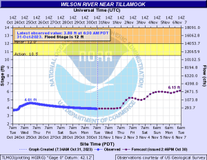
Thursday will be another cloudy, rainy, and windy day, winds southerly 15-25 gusting to 35, the high near 61. Then we transition over to showers Thursday night, the winds easing, lows near 49. The rain total for this first system is likely in the range of 2-4” for the two-day event, Wednesday and Thursday, though there may be some isolated spots seeing upward of 5”. So far, river flooding is not expected but there may be some Urban and Small Stream Flooding from the prolonged moderate rain.

Friday starts out mostly cloudy with more scattered showers, the high near 62, then we are faced with another front and atmospheric river event that arrives that night so look for another cloudy, rainy, and breezy period to start and this time there is also a chance of thunderstorms, the low around 51.

Saturday, we see more rain with possible thunderstorms, then in the afternoon we transition to showers, chance of some thunderstorms continues, still on the breezy side, the high near 61. The activity continues Saturday night, lows near 51. Now for this event, the models have been sending some mixed signals on the exact timing, if it will be a weak to moderate atmospheric river event, and on the amount of rainfall we can expect. Considering the river flow rates will already be higher from the first event, this one bears a little closer watching. For now, it still does not appear that flooding concerns would be elevated. All things considered; it is worth watching what the next few models show as the picture should come into better focus, so, stay tuned!

As for Sunday and Monday, still cloudy and breezy with scattered showers, highs near 59, lows near 49.

Here is a look at the Wilson River Forecast issued yesterday afternoon:

Slide Slide Slide Slide Slide Slide Slide Slide Subscribe Contribute

Ads

Featured Video

Tillamook Weather

Tides

Tillamook County Pioneer Podcast Series

Tillamook Church Search

Cloverdale Baptist Church
Nestucca Valley Presbyterian
Tillamook Ecumenical Service

Archives

  • Home
  • EULA Privacy Policy
  • Contact
  • Opt-out preferences
  • Search...
Share on facebook
Facebook
Share on pinterest
Pinterest
Share on twitter
Twitter
Share on linkedin
Linkedin
Catherine

Recent Posts

  • TILLAMOOK COUNTY CREAMERY ASSOCIATION WORK-STUDY PROGRAM CREATES OPPORTUNITIES

    June 30, 2025
  • TILLAMOOK POLICE DEPARTMENT: Damascus Man Sentenced to 28 Years for Attempted Murder of Law Enforcement Officers in Tillamook County

    June 30, 2025
  • BOOK REVIEW: Abundance by Ezra Klein & Derek Thompson

    June 29, 2025
©2025 | Theme by SuperbThemes

Manage Cookie Consent
To provide the best experiences, we use technologies like cookies to store and/or access device information. Consenting to these technologies will allow us to process data such as browsing behavior or unique IDs on this site. Not consenting or withdrawing consent, may adversely affect certain features and functions.
Functional Always active
The technical storage or access is strictly necessary for the legitimate purpose of enabling the use of a specific service explicitly requested by the subscriber or user, or for the sole purpose of carrying out the transmission of a communication over an electronic communications network.
Preferences
The technical storage or access is necessary for the legitimate purpose of storing preferences that are not requested by the subscriber or user.
Statistics
The technical storage or access that is used exclusively for statistical purposes. The technical storage or access that is used exclusively for anonymous statistical purposes. Without a subpoena, voluntary compliance on the part of your Internet Service Provider, or additional records from a third party, information stored or retrieved for this purpose alone cannot usually be used to identify you.
Marketing
The technical storage or access is required to create user profiles to send advertising, or to track the user on a website or across several websites for similar marketing purposes.
Manage options Manage services Manage {vendor_count} vendors Read more about these purposes
View preferences
{title} {title} {title}