Menu
  • Home
  • Breaking News
  • Feature
    • Arts
    • Astrology
    • Business
    • Community
    • Employment
    • Event Stories
    • From the Pioneer
    • Government
    • Letters to the Editor
    • Non Profit News
    • Obituary
    • Public Safety
    • Podcast Interview Articles
    • Pioneer Pulse Podcast: Politics, Palette, and Planet – the Playlist
  • Weather
  • Guest Column
    • Perspectives
    • Don Backman Photos
    • Ardent Gourmet
    • Kitchen Maven
    • I’ve been thinking
    • Jim Heffernan
    • The Littoral Life
    • Neal Lemery
    • View From Here
    • Virginia Carrell Prowell
    • Words of Wisdom
  • Things to do
    • Calendar
    • Tillamook County Parks
    • Tillamook County Hikes
    • Whale Watching
    • Tillamook County Library
    • SOS Community Calendar
  • About
    • Contribute
    • Advertise
    • Subscribe
    • Opt-out preferences
  • Post Submission Test
  • Search...
Menu

GORDON’S UPDATE: Weather – 11/3/22; Time Change Sunday, Nov. 6

Posted on November 3, 2022 by Editor
www.tillamookcountypioneer.net

By Gordon McCraw, Meteorologist for the Tillamook County Pioneer
Thursday, November 3, 2022
Weather

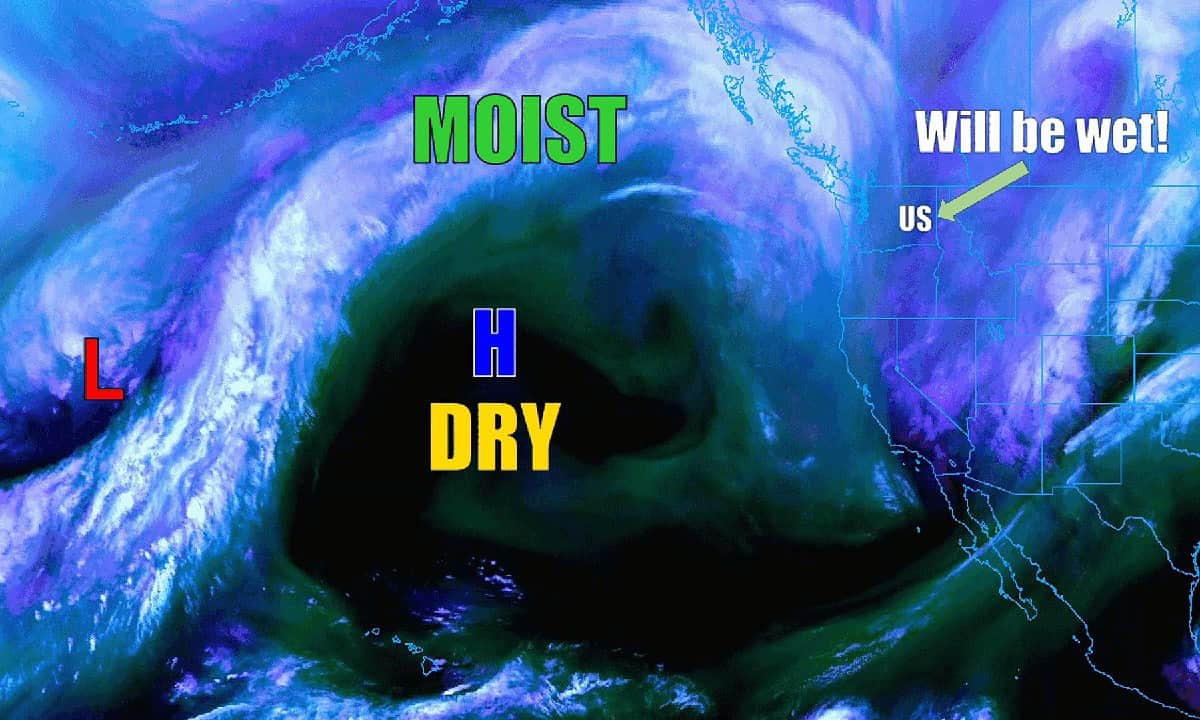
Well, things are starting to take shape with the atmospheric river already developing to the north pushing rain into British Columbia down to Vancouver Island. This gave us a brief period of dry this morning but then a warm front started to bring in some light rain late this afternoon. Then tonight things will start to ramp up with the rain increasing, as well as the winds becoming southerly 14-18 gusting to 30, the temperature actually rises tonight up to around 53.

Tomorrow, Friday, the cold front/atmospheric rive starts to drift southward and bring rain, moderate, occasionally heavy, especially in the afternoon and evening over our area. For now, the core of the heaviest rain appears to be aimed at southwestern Washington, but we all know that could change with the next model run, and being this close, it wouldn’t take much to have it drop into northwestern Oregon. At any rate, the forecast for now is for tomorrow to be rainy and windy, and the rain could be heavy at times, winds increase to southwesterly 20-25 gusting to 40 with gusts to 50-60 possible at the beaches. The high tomorrow around 57.

More rain tomorrow night, heavy at times as the front passes over, winds becoming westerly 20-25 gusting to 40 but becoming northwesterly 10-15 gusting to 25 after midnight, lows down to near 42. Again, I say, for now it looks like we will see somewhere around 2-4” of rain Friday with the Coast Range seeing upwards of 3-5” which would push the rivers up several feet, but the current forecast still keeps them several feet below Action Stage. Individuals and businesses in flood prone areas should keep a close eye on this for any changes though. As has been the case in the past, the timing and exactly which watershed will see how much rain is very difficult to pin down for these events. Also, during periods of heavy rain, urban and small stream flooding can occur.

So, we see more rain Saturday morning, but it will get pushed to the south by an upper level trough of low pressure and we transition back to showers, highs Saturday near 50, lows dropping down to near 38.

Sunday, we see another fast moving cold front push through so expect another rainy day with the front passing to the south by around 9PM when we again have a cold trough of low pressure bring in showers and colder surface temperatures that pushes down the snow levels also. Sunday the high near 47, lows that night near 35, the snow level around 2000-2500’. Monday more scattered showers with highs near 47, lows near 33 then Tuesday, showers, the snow level falls to near 1900’, the high near 45, lows Tuesday night, still with showers, falls to near 30 so it is possible the area could see some low level snow after around midnight Tuesday.

Wednesday morning a chance of rain and/or snow showers then the snow level starts to lift to near 1000’ mid morning and continue climbing to near 1700’ in the afternoon. Obviously, the Coast Range Passes will be seeing accumulating snow during this time also making driving across the summit hazardous at times.

“FALL BACK” – Return to Standard Time – Sunday November 6th
A reminder also that Sunday we “Fall-Back”, or shift from Daylight Savings Time back to Standard Time, officially at 2AM Sunday.

Featured Video

Slide Contribute SUBSCRIBE

Tillamook Weather

Tides

Tillamook County Pioneer Podcast Series

Tillamook Church Search

Cloverdale Baptist Church
Nestucca Valley Presbyterian
Tillamook Ecumenical Service

Archives

  • Home
  • EULA Privacy Policy
  • Contact
  • Opt-out preferences
  • Search...
Share on facebook
Facebook
Share on pinterest
Pinterest
Share on twitter
Twitter
Share on linkedin
Linkedin
Catherine

Recent Posts

  • TILLAMOOK COUNTY PIONEER WEEK IN REVIEW 5/8/25

    May 8, 2025
  • Exciting News for North County Recreation District – Congratulations to Barbara McCann on Retirement; Welcome New Executive Director, Justin Smith; Special Saturday Swims this Spring to Honor Legacy Pool – May 10 & June 14

    May 8, 2025
  • "I Pledge Allegiance" ... We Take an Oath

    May 8, 2025
©2025 | Theme by SuperbThemes

Manage Cookie Consent
To provide the best experiences, we use technologies like cookies to store and/or access device information. Consenting to these technologies will allow us to process data such as browsing behavior or unique IDs on this site. Not consenting or withdrawing consent, may adversely affect certain features and functions.
Functional Always active
The technical storage or access is strictly necessary for the legitimate purpose of enabling the use of a specific service explicitly requested by the subscriber or user, or for the sole purpose of carrying out the transmission of a communication over an electronic communications network.
Preferences
The technical storage or access is necessary for the legitimate purpose of storing preferences that are not requested by the subscriber or user.
Statistics
The technical storage or access that is used exclusively for statistical purposes. The technical storage or access that is used exclusively for anonymous statistical purposes. Without a subpoena, voluntary compliance on the part of your Internet Service Provider, or additional records from a third party, information stored or retrieved for this purpose alone cannot usually be used to identify you.
Marketing
The technical storage or access is required to create user profiles to send advertising, or to track the user on a website or across several websites for similar marketing purposes.
Manage options Manage services Manage {vendor_count} vendors Read more about these purposes
View preferences
{title} {title} {title}