Menu
  • Home
  • Breaking News
  • Feature
    • Arts
    • Astrology
    • Business
    • Community
    • Employment
    • Event Stories
    • From the Pioneer
    • Government
    • Letters to the Editor
    • Non Profit News
    • Obituary
    • Public Safety
    • Podcast Interview Articles
    • Pioneer Pulse Podcast: Politics, Palette, and Planet – the Playlist
  • Weather
  • Guest Column
    • Perspectives
    • Don Backman Photos
    • Ardent Gourmet
    • Kitchen Maven
    • I’ve been thinking
    • Jim Heffernan
    • The Littoral Life
    • Neal Lemery
    • View From Here
    • Virginia Carrell Prowell
    • Words of Wisdom
  • Things to do
    • Calendar
    • Tillamook County Parks
    • Tillamook County Hikes
    • Whale Watching
    • Tillamook County Library
    • SOS Community Calendar
  • About
    • Contribute
    • Advertise
    • Subscribe
    • Opt-out preferences
  • Post Submission Test
  • Search...
Menu

GORDON’S UPDATE: Weather 12/13/22

Posted on December 13, 2022December 13, 2022 by Editor

By Gordon McCraw, Meteorologist for the Tillamook County Pioneer
Tuesday, December 13, 2022

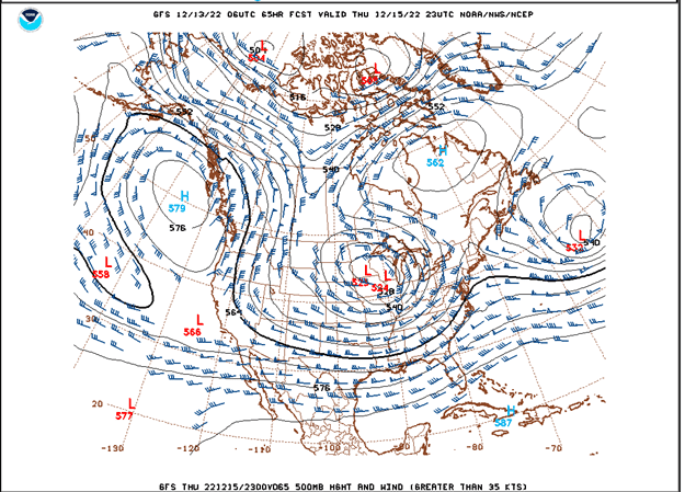
A little weather lesson today. The current weather picture is, we have a low pressure area well off to the west of northern California with another low pressure area off to the east while we have a dome of high pressure sandwiched between and over the Pacific Northwest including Tillamook. This is a pretty typical definition of a Blocking High Pressure Ridge, also known as an Omega Block because of its shape. When we get this synoptic situation, it is known to persist for several days. Attached is the actual model output showing the pattern for Thursday, showing this forecast scenario.


So, with high pressure over the area this evening, we see partly cloudy skies, but we likely see some patchy fog developing late, and with light east winds and radiational cooling, the low drops to near 32.

With that high pressure ridge still firmly in place, tomorrow, Thursday, and Friday look sunny, after the morning patchy fog burns off, winds northeasterly 4-8, high near 47, with mostly clear nights and light winds, the patchy early morning fog returns, lows near 31.

By Saturday the models start getting mixed. Some say the ridge holds and we stay dry and cold, others say a trough of low pressure drops down and brings some precipitation to the area. As the nighttime temperature would still be at or below freezing, some low level snow would be possible. So, Saturday and Sunday look partly to mostly cloudy with a chance of rain during the day, and a chance of snow at night when the temperature drops down near or below 32 degrees. This also spells accumulating snow possible again in the Coast Range. Even the valley could see some low level snow over the weekend on into Monday. Stay Tuned!

Featured Video

Slide Contribute SUBSCRIBE

Tillamook Weather

Tides

Tillamook County Pioneer Podcast Series

Tillamook Church Search

Cloverdale Baptist Church
Nestucca Valley Presbyterian
Tillamook Ecumenical Service

Archives

  • Home
  • EULA Privacy Policy
  • Contact
  • Opt-out preferences
  • Search...
Share on facebook
Facebook
Share on pinterest
Pinterest
Share on twitter
Twitter
Share on linkedin
Linkedin
Catherine

Recent Posts

  • TILLAMOOK COUNTY PIONEER WEEK IN REVIEW 5/8/25

    May 8, 2025
  • Exciting News for North County Recreation District – Congratulations to Barbara McCann on Retirement; Welcome New Executive Director, Justin Smith; Special Saturday Swims this Spring to Honor Legacy Pool – May 10 & June 14

    May 8, 2025
  • "I Pledge Allegiance" ... We Take an Oath

    May 8, 2025
©2025 | Theme by SuperbThemes

Manage Cookie Consent
To provide the best experiences, we use technologies like cookies to store and/or access device information. Consenting to these technologies will allow us to process data such as browsing behavior or unique IDs on this site. Not consenting or withdrawing consent, may adversely affect certain features and functions.
Functional Always active
The technical storage or access is strictly necessary for the legitimate purpose of enabling the use of a specific service explicitly requested by the subscriber or user, or for the sole purpose of carrying out the transmission of a communication over an electronic communications network.
Preferences
The technical storage or access is necessary for the legitimate purpose of storing preferences that are not requested by the subscriber or user.
Statistics
The technical storage or access that is used exclusively for statistical purposes. The technical storage or access that is used exclusively for anonymous statistical purposes. Without a subpoena, voluntary compliance on the part of your Internet Service Provider, or additional records from a third party, information stored or retrieved for this purpose alone cannot usually be used to identify you.
Marketing
The technical storage or access is required to create user profiles to send advertising, or to track the user on a website or across several websites for similar marketing purposes.
Manage options Manage services Manage {vendor_count} vendors Read more about these purposes
View preferences
{title} {title} {title}