Menu
  • Home
  • Breaking News
  • Feature
    • Arts
    • Astrology
    • Business
    • Community
    • Employment
    • Event Stories
    • From the Pioneer
    • Government
    • Letters to the Editor
    • Non Profit News
    • Obituary
    • Public Safety
    • Podcast Interview Articles
    • Pioneer Pulse Podcast: Politics, Palette, and Planet – the Playlist
  • Weather
  • Guest Column
    • Perspectives
    • Don Backman Photos
    • Ardent Gourmet
    • Kitchen Maven
    • I’ve been thinking
    • Jim Heffernan
    • The Littoral Life
    • Neal Lemery
    • View From Here
    • Virginia Carrell Prowell
    • Words of Wisdom
  • Things to do
    • Calendar
    • Tillamook County Parks
    • Tillamook County Hikes
    • Whale Watching
    • Tillamook County Library
    • SOS Community Calendar
  • About
    • Contribute
    • Advertise
    • Subscribe
    • Opt-out preferences
  • Post Submission Test
  • Search...
Menu

GORDON’S UPDATE: Weather 12/22/22 – Local Forecast, Up-to-date Information

Posted on December 22, 2022December 22, 2022 by Editor

By Gordon McCraw, Meteorologist for the Tillamook County Pioneer
Thursday, December 22, 2022

First, to give a perspective on the forecast, I am writing this at about 2:30PM after attending a Special Weather Briefing from the National Weather Service.
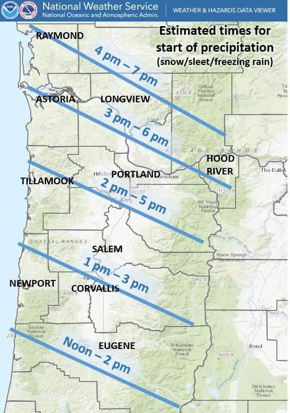
Currently the Artic air continues to be pushed into the area by the strong easterly winds that are blowing 20-25 gusting to 30 across the area. This is making the current temperature of 32 feel like it is around 15-20 degrees with the windchill. Next on the agenda is moisture being pushed northeastward by an approaching warm front that is moving in from our southwest. As I type this, there are reports of precipitation in the Eugene area and Springfield is seeing snow. As I have been mentioning, for us, we likely first see snow starting in the next few hours, then as the warmer air pushes in above the surface levels, the snow will melt in the warmer area before refreezing before it hits the ground in the form of sleet, maybe as early as 4PM. Shortly after that, as the warm layer thickens the moisture does not have enough time to refreeze, so it hit the ground as rain, but as the surface temperatures are still below freezing, it ices over on the ground, this is called freezing rain, this likely happening by maybe 5-6 or 7PM tonight.

The freezing rain will continue tonight, and we see maybe 0.1-0.3” of ice buildup from the event, but as the warm air layer thickens, it will finally warm up the surface temperatures in the early morning hours tomorrow, Friday. This will be aided by the winds becoming more southeasterly, still 20-25 gusting to 35. The overnight low temperature will actually be increasing to just above freezing before sunup, when it typically is the coldest which is a good sign.

The temperatures will continue to climb tomorrow morning so the ice event will come to a close west of the Coast Range with the afternoon high around 49, but should you have travels plans across the Coast Range, it will take a while longer for them to see the improving conditions as their temperatures were much colder to start plus the north valley temperatures and winds will be such that their transition will also be slower which will impact the east side of the passes. And remember, they will be seeing snow, then ice with accumulations as high as ½”. They likely do not transition to rain until tomorrow afternoon, even later on the east side of the passes. To make life more fun across the passes, they do fall below freezing again Friday night so more freezing rain is possible on top of the refreezing ground moisture.
Back to Tillamook for Friday night, we will continue to be cloudy and rainy, but the southerly winds ease and the low only drops to near 43.

Christmas Eve we remain cloudy and rainy with breezy southerly winds 10-15 gusting to 35, the high near 54, the rain eases some later that night for Santa, lows near 44. Total rainfall about an inch.

Christmas Day, yep, more rain, maybe not a much as the day before, highs near 55, the rain and winds increases Christmas night, lows near 49.

As for next week, the models still suggest periods of heavy rain possible as a trough and its associated low pressure area moves into the region. This continues to signal the possibility of hydrological issues for our rivers, especially the Nehalem, maybe even the Wilson River. Something to watch for after the holiday weekend.

Featured Video

Slide Contribute SUBSCRIBE

Tillamook Weather

Tides

Tillamook County Pioneer Podcast Series

Tillamook Church Search

Cloverdale Baptist Church
Nestucca Valley Presbyterian
Tillamook Ecumenical Service

Archives

  • Home
  • EULA Privacy Policy
  • Contact
  • Opt-out preferences
  • Search...
Share on facebook
Facebook
Share on pinterest
Pinterest
Share on twitter
Twitter
Share on linkedin
Linkedin
Catherine

Recent Posts

  • TILLAMOOK COUNTY PIONEER WEEK IN REVIEW 5/8/25

    May 8, 2025
  • Exciting News for North County Recreation District – Congratulations to Barbara McCann on Retirement; Welcome New Executive Director, Justin Smith; Special Saturday Swims this Spring to Honor Legacy Pool – May 10 & June 14

    May 8, 2025
  • "I Pledge Allegiance" ... We Take an Oath

    May 8, 2025
©2025 | Theme by SuperbThemes

Manage Cookie Consent
To provide the best experiences, we use technologies like cookies to store and/or access device information. Consenting to these technologies will allow us to process data such as browsing behavior or unique IDs on this site. Not consenting or withdrawing consent, may adversely affect certain features and functions.
Functional Always active
The technical storage or access is strictly necessary for the legitimate purpose of enabling the use of a specific service explicitly requested by the subscriber or user, or for the sole purpose of carrying out the transmission of a communication over an electronic communications network.
Preferences
The technical storage or access is necessary for the legitimate purpose of storing preferences that are not requested by the subscriber or user.
Statistics
The technical storage or access that is used exclusively for statistical purposes. The technical storage or access that is used exclusively for anonymous statistical purposes. Without a subpoena, voluntary compliance on the part of your Internet Service Provider, or additional records from a third party, information stored or retrieved for this purpose alone cannot usually be used to identify you.
Marketing
The technical storage or access is required to create user profiles to send advertising, or to track the user on a website or across several websites for similar marketing purposes.
Manage options Manage services Manage {vendor_count} vendors Read more about these purposes
View preferences
{title} {title} {title}