By Gordon McCraw, Meteorologist for the Tillamook County Pioneer
The synoptic (overall) weather pattern has not changed except for subtle shifts now and then during the past month. We still have low pressure areas that develop in the Gulf of Alaska then drift southeastward into British Columbia. We also have a ridge of high pressure over the Rockies that has been pretty much stationary for a while. We may notice the sunsets have more orange in them as a thin layer of smoke appears to have covered much of western Oregon though the heavier smoke is moving northeastward in the upper level flow.
So, the big picture this week is the ridge to the east will strengthen and this will influence our weather by helping to give us relatively cloud free days and partly cloudy nights with persistent slightly warmer temperatures.
So, the “official” forecast for tonight is mostly clear skies with winds northerly 5-10 gusting to 18 but diminishing, lows near 52.
We have a few clouds possible tomorrow morning that quickly burn back leaving a sunny day, winds becoming northwesterly 10-15 gusting to 20, highs near 70, a mostly clear night, the winds again diminish, lows near 52.
After that, summer continues with mostly sunny days, highs near 71, and partly cloudy nights, lows near 54 through Friday.
Then the weekend, well, there is nice, and then there is nicer. Look for sunny skies Saturday and Sunday with the high temperatures climbing to near 74, with mostly clear nights, lows near 56.
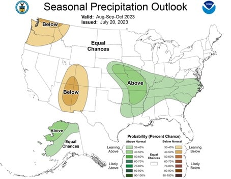
The long range models from the Climate Prediction Center suggest a 40-50% chance of warmer than normal temperatures for the three month period Aug-Sept-Nov, with a 30-40% chance of below normal rainfall.


