
By Gordon McCraw for the Tillamook County Pioneer
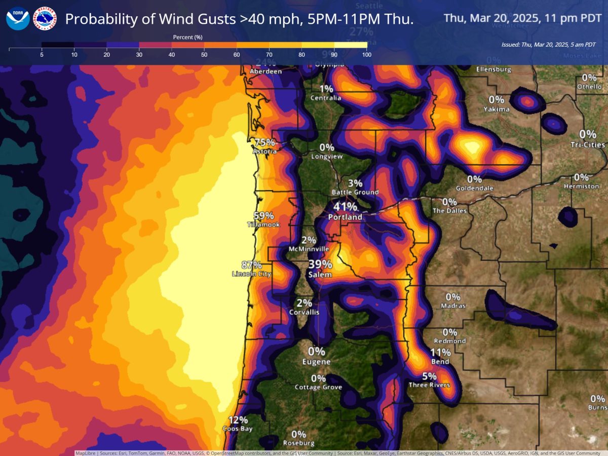
Well, happy first day of spring everyone, but sorry, the rainy periods continue. In the last 24 hours, Tillamook has seen between around ½ to a little over ¾” of rain, thanks to yet another front and disturbance that continues to push rain across the region. It looks like we will see more rain today that transitions to showers with possible thunderstorms, as more unstable air pushes in behind the front this afternoon. We can also expect breezy southerly winds of 10-15 gusting to 30 today with gusts to 45 possible down at the beaches. This activity will continue tonight with the upslope affect from the mountains squeezing out more rain into Friday morning. We continue to see the gusty winds tonight also, the low temperature near 47.
We see another front bringing more rain tomorrow, Friday, the winds southwesterly 8-12 gusting to 25, afternoon highs near 52. Look for more showers behind the front tomorrow night, the wind diminishes after around midnight, lows near 39.
As for the weekend, the scattered post-frontal showers continue Saturday under mostly cloudy skies, with light wind in the afternoon high temperature near 54, lows near 43. It looks like another atmospheric river sets up Sunday, fortunately aimed to the north into the Vancouver Island area, which could still push some rain into our area Sunday, the high near 56. Back over to scattered showers Sunday night as we see a ridge of high pressure starting to build in which caps the shower activity after around midnight, lows near 43.
After all that, it looks like spring may make an appearance for the first half of next week as stronger high pressure builds in bringing some fair skies and warmer temperatures through midweek. Unfortunately, the fair and mild conditions look to be replaced by cooler and wetter conditions the second part of next week.
Lastly, as far as any Advisories, Watches or Warnings issued for the area, there is a slight chance we could see a Wind Watch issued for the coastal area and a Gale Warning for the coastal waters later today. All that’s in effect currently though are, a Hazardous Seas Warning until 5pm today for very steep and hazardous seas offshore, and a Small Craft Warning also valid through 5pm this evening. Looking at the river forecasts shows little to no hydrological concerns.
That’s it for this edition folks. Until Monday, this is meteorologist Gordon McCraw hoping you all have a wonderful weekend.