By Gordon McCraw, Meteorologist for the Tillamook County Pioneer
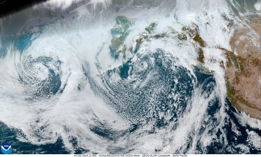
The driving pattern this week stems from a large low pressure area up in the Gulf of Alaska and its associated low pressure trough that extends down into the eastern Pacific. This will provide systems a path that allows several fronts to pass across the region this week. The first front pushed in some mainly light rain this afternoon which persists tonight as the weakening front stalls over northwest Oregon. The rain does ease further tonight by around midnight, and with light winds, the lows drop to near 51.
Tomorrow looks cloudy and rainy also as another system approaches that enhances the rain chance by the afternoon, winds becoming westerly 4-8, the high near 60, rainy still tomorrow night, light winds the low near 47. Rain amounts tomorrow range from around 0.10” to near 0.25”, maybe a little more in the Coast Range.
So, rainy on Wednesday, winds becoming southerly 8-12 gusting to 18, then shifting to westerly as the front passes that morning, the high near 59. In marches another wet front Wednesday night, so rain continues, until that system passes around midnight, leaving post-frontal showers with a chance of thunderstorms, light winds, the low near 44.
We see continued scattered showers with possible thunderstorms Thursday as an upper level trough of low pressure moves over the area, the afternoon high near 56, then with the northwesterly flow pushing in more moisture, Thursday night is rainy again, the low near 42.
The models suggest a ridge will be trying to build in Friday so the rain chances decrease somewhat, the high near 58, then things get a little mixed as it looks like a disturbance will ride over the ridge and bring in more rain Friday night into Saturday, then things get even more confusing as the flow appears to flatten out which would lend itself to more moisture riding in on the flow Sunday into Monday when we start to possibly watch a low pressure area dropping down the coast towards northern California from British Columbia, so the extended forecast is looking wet also. High temperatures over the weekend in the low 60s, lows in the upper 40s.
I should mention also that, resulting from the flow associated with the incoming front, we do still have a Beach Hazards Statement through this evening for the north and central coastal area for an increased possibility of Sneaker Waves resulting from the larger swells getting pushed in. I say increased because there is always a chance of sneaker wave along our coast, as many of you know!
I know I’ve said “rain” a lot in this week’s forecast, fortunately the hydrological concerns are still minimal with this rain as all the rivers are still very low. This will increase the flow rates a little, just enough to get the fishermen excited. Hopefully, this does not change next week as it continues to look wet in the extended forecast also.
And just to get you real excited, how about I mention the chance of SNOW. So, the Cascade passes are looking at the snow level dropping to around 4,000’ Wednesday night, so if you are headed over the Santiam Pass for any reason, it is starting to be that time when you will want to look in on Tripcheck before you go, to see what is happening on your route.
Welcome to Fall everyone!


