By Gordon McCraw, Meteorologist for the Tillamook County Pioneer
A mostly sunny, but chilly weekend with the highs around 64 but the low falling to 36 this morning under the clear skies. Today, the last day of September, we saw the high pressure ridge building and drifting east into the area and this gave us mostly clear skies except for some thin high clouds blowing across. What all this did do for us was to push the afternoon temperature into the low 70s with an easterly, or offshore wind.
Tonight, we see a few clouds moves across as the ridge flattens some with a weak disturbance riding across the top of the ridge, as it continues to drift east across the area. We do see some light offshore winds still tonight and the low only dips to near 49. For those of you in wind protected areas, your temperature could be as much as 10 degrees cooler — make that “colder”!
Tomorrow looks to be another sunny, fair and mild day as the area is still under the influence of the ridge, the onshore winds will be returning and by the afternoon we see westerly winds 4-8, the afternoon high up near 70. Tomorrow night the clouds increase with a weak front moving across that could squeeze out a light shower, however slight that chance. The winds tomorrow night will be light and becoming northerly, the low near 46.
With the front past the area Wednesday, we can expect mostly sunny skies with the winds becoming northerly 10-15 gusting to 20, the high a cooler 64, and with partly cloudy skies Wednesday night, and light winds, the low again drops to near 45.
Thursday looks to have a weak ridge of high pressure moving across that would bring a sunny and mild day with the high up near 70 again, then a mostly clear night, lows near 49.
The models show a decent upper level trough of low pressure for Friday that would bring a better chance of some scattered showers starting by the afternoon, and persisting through Friday night, with that chance decreasing after around midnight. It is looking like the weekend will be mostly sunny with highs in the upper 60s. Some of the models do show weak disturbances riding over a relatively zonal flow so, while there are no showers forecasted, the chance is not a zero probability at this point.
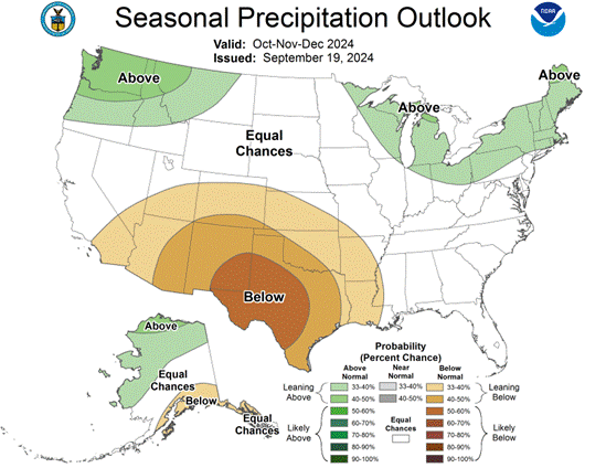
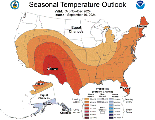
Now for the Climate Prediction Centers extended Outlook for October and beyond. They are forecasting a chance of above normal temperatures for the first half of October, and a near normal chance of precipitation for October (issued yesterday). A look at the Seasonal Outlook for October-November-December (issued September 19th), they are forecasting a 40-50% chance of above normal Precipitation, and equal chances of above or below normal Temperatures. I will update this when the new Outlook is issued after the middle of next month.


