")

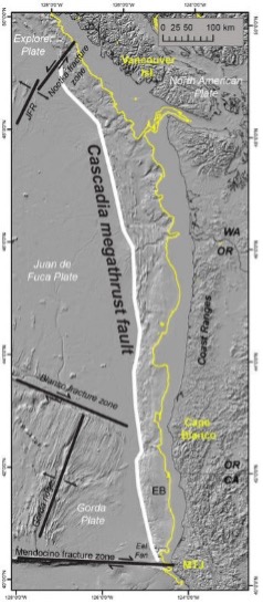
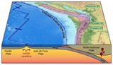
Today, January 26, 2022, marks the 322nd anniversary of the 1700 AD Cascadia earthquake – the largest known earthquake to have occurred in the “lower 48” United States. This (estimated) magnitude 8-9 earthquake ruptured along the 1300-km-long Cascadia subduction zone which sits off the coast of northern California, Oregon and Washington. Here, the eastern margins and dense oceanic crust of the Gorda and Juan De Fuca plates meet their demise as they subduct beneath the lighter continental crust of the north American plate. When enough stress builds up along this plate boundary interface or “megathrust” fault, very, very big earthquakes can occur.
The 1700 Cascadia earthquake set off a tsunami that not only struck Cascadia’s Pacific coast, but also crossed the Pacific Ocean to Japan, where it damaged coastal villages. Written records of the “orphan tsunami” pinpoint the earthquake to the evening of January 26, 1700. Evidence of drowned “ghost” forests along the Washington coast reveal regions of inundation from the tsunami waves and tree ring dating from these forests match up with the timing of the tsunami in Japan.
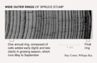 The rings show no sign of lengthy suffering from gradual drowning and salt-water poisoning from a drawn-out sea-level rise. Instead, wide rings to the end suggest that the tree was healthy right up to the time of its death… Sudden subsidence (or rapid down dropping of the Earth’s surface from something like an earthquake) provides a simple explanation for tree rings like these.
Evidence of large earthquakes and the damage they can pose help us prepare for similar events in the future. To learn more about Cascadia and on-going @USGS research visit:
Here is an article by OPB with more information and resources:
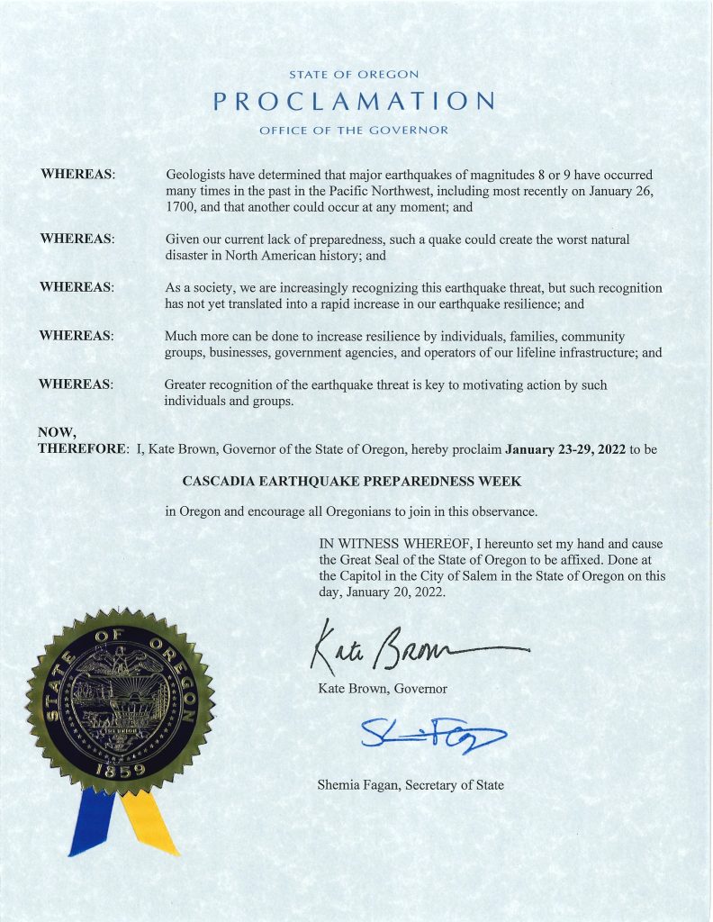 This week is Cascadia Earthquake Preparedness Week, encouraging Oregonians to prepare and practice earthquake safety. Wednesday, January 26, will mark 322 years since the last Cascadia Subduction Zone (CSZ) earthquake and tsunami struck the Pacific Northwest. Scientists predict the chances that a mega-CSZ earthquake will occur within the next 50 years are about one in ten. OEM wants to empower Oregonians to stay informed about the hazards and make plans to protect themselves, their families, and their communities. Learn more about earthquakes in Oregon and how to prepare at https://go.usa.gov/xt58n.
 Learn how to be prepared for an earthquake or any disaster by being #2WeeksReady: go.usa.gov/xtRKk. Have a plan and enough supplies for you and your household to survive on your own for a full two weeks should a disaster occur. This may sound overwhelming, but you’re probably more prepared than you think.