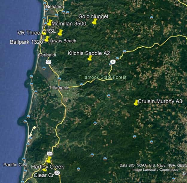
Oregon Department of Forestry has sent out notice of multiple slash burns starting today October 31, 2022. See the map below for areas/locations.
Landowner/Operator: ODF
Unit Legal Lat/Long Acres/Tons Est. Ignition Location
Kilchis Saddle 1N 8W 30 45.545 -123.7149 82/354 1000 8 mi NE of Tillamook
Cruisin Murphy A3 2S 7W 12 45.411 -123.4877 90/180 1200 16 mi SE of Tillamook
Landowner/Operator: L& C Tree Farms LLC
Unit Legal Lat/Long Acres/Tons Est. Ignition Location
McMillan 2N 10W 21 45.649 -123.916 21/420 1000 13 mi NW of Tillamook
Hartley Creek 4S 10W 23 45.2075 -123.862 20/396 1300 16 mi S of Tillamook
Clear Creek 4S 10W 35 45.1798 -123.8801 25/498 1400 18 mi S of Tillamook
Ballpark1320 1N 10W 4 45.5968 -123.9212 16/324 1100 11 mi NW of Tillamook
Landowner/Operator: Stimson
Unit Legal Lat/Long Acres/Tons Est. Ignition Location
VR Three 2N 10W 26 45.618 -123.937 30/130 1000 12 mi NW of Tillamook
VR3L 2N 10W 36 45.619 -123.863 49/160 1000 12 mi N of Tillamook
Omelet 2N 10W 12 45.669 -123.858 67/200 0930 12 mi N of Tillamook
Gold Nugget 2S 8W 6 45.427 -123.707 62/175 1400 7 mi NE of Tillamook


