By Gordon McCraw, Meteorologist for Tillamook County Emergency Management
Thursday, June 9, 2022, 10:00am
Weather
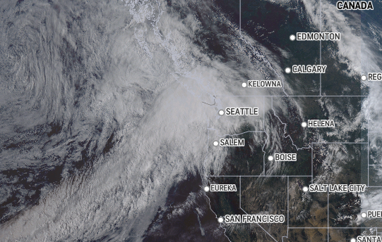
Well, the satellite picture clearly shows a long southwesterly flow setting up that has several enhanced areas of moisture with subtropical origin. This is yet another late season Pineapple Express, now know an Atmospheric River. Rain is already moving into Washington up into Vancouver Island area this morning with some light rain also into Astoria. We would expect this to drift south some today bringing rain into our area later this afternoon, so today’s forecast is for mostly cloudy to cloudy skies, the rain moves in later this afternoon, winds becoming southerly 8-12 gusting to 20, the high near 66. The rain continues tonight into the early morning hours, winds southerly 8-12 gusting to 25, lows only falling to a muggy 57 degrees.
Tomorrow a disturbance will rotate towards the area so more rain likely, winds southerly 4-8, highs near 66, still rainy tomorrow night, lows near 55. The two-day rainfall total appears to be around 1-3” of rain with the higher amounts falling in the Coast Range with a slight chance of higher amounts north of Tillamook.
The rain transitions to rainshowers later Saturday morning then they become more scattered Saturday night into Sunday with a few more showers possible on Monday before high pressure builds in, and we see partly sunny skies for Tuesday. Temperatures will be in the lows 60s during this period, lows in the upper 40s. The long range models suggest showers could return for Wednesday.
This looks to be a heavy rain event for areas in the far northwest Oregon area into Washington and even over in the Cascades. A look at the river forecasts shows our rivers do react to the rain but not significantly so flooding concern continue to remain low. Even if the coast range received 3-5” of rain over the next few days, this would not be enough to cause river flooding from this event. The areas of concern are those rivers that use reservoir for flood control. These are typically used for that purpose in the winter months when the reservoirs are already in a low state but they are near, or at full now so they will be less able to be use for this purpose which increases the flood risk on those rivers. Again, none of these are in Tillamook County.
Wildfire Season 2022
At some point this weather will change and we will transition to the dryer summer-like weather pattern where our wildfire risks become more elevated. The wild wildfire season from a couple years ago is still on the minds of many as the affected people continue to deal with the aftereffects of that, like our neighbors to the south in Otis. One important lesson learned was being prepared, to have a plan on what you and your family (including your pets) are going to do, on where you will go, and how you can stay informed. Today I ran across a website that can help with the “staying informed” part.
The Oregon Wildfire Response and Recovery has developed a website called 2022 Wildfire Season Situation Overview. They are working with each jurisdiction, their agencies and partners to provide consistent and verified date to help you stay informed thru this site. The website is: https://wildfire.oregon.gov/pages/current-conditions.aspx
This site offers a lot of information and is a great source to help you stay informed on any threats. The preparedness part is on you.
Help with developing plans and other preparedness information can be found at ready.gov.
Are you ready?


