By Gordon McCraw
Another chilly morning with the low morning temperature dropping down to a cold 28 degrees. It looks like we had a few upper level clouds push up across the area today that were wrapping around the low pressure area off of northern California. Other than this we see little change tonight with mostly clear skies with light east winds, the low drops to near 32 so the frost likely returns in the early morning hours.
We start out with a mostly sunny day tomorrow with light westerly winds, the high near 53, then some clouds move in tomorrow night ahead of a weak front that is dropping southeastward into the area, light southeasterly winds, lows near 37.
The rain moves in early Thursday morning, winds southerly 5-10, highs near 49, rainy Thursday night, lows near 39.
Another front moves in on Friday, bringing rain and winds gusting to near 35 by the afternoon, higher gusts at the beaches, highs near 51, then transitioning to showers with possible thunderstorms Friday night, breezy still, lows near 41.
Another warm front rotates in on Saturday so we continue with the cloudy, rainy, and breezy conditions into Sunday when we see windy conditions returning also, highs near 57, lows Sunday night only down to near 48.
The start of next week looks cloudy and rainy still with a possible atmospheric river developing!
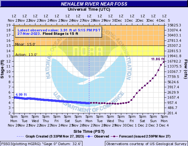
As I have mentioned in an earlier report, the forecasted river levels are starting to show some significant increases over the weekend and into next week. Currently the only river threatening to reach Action Stage is the Nehalem River, cresting around December 6th. The Wilson, Trask, and Nestucca Rivers all crest several feet below Actions Stage. There are several rivers in the valley that could reach bankfull as well. As is ALWAYS the case. The important thing now is to watch for the trends, are the future forecasts trending higher or lower as we all know, the forecast will change from computer run to run and day to day. I have included the latest Nehalem River graph with this report.

Listen here:


